Social Studies Unit 2 Test: Maps, Geography & Our World
Name Date
Part 1: Map Skills
Look at the map of Lake Town. Use the key and the compass rose to answer.
Map of Lake Town
This map shows Lake Town from above. The key tells what each symbol means. The compass rose shows north, south, east and west.
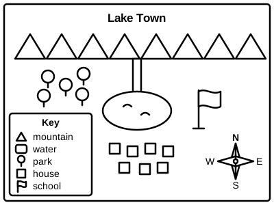
Key: brown triangle = mountain, blue = water, green tree = park, small square = house, flag = school.
- What does the green tree stand for on this map?
- Which direction is the school from the lake?northsoutheastwest
- The river flows from the mountains down to the lake. Which direction does it flow?northsoutheastwest
- Are the houses north or south of the lake?northsouth
Part 2: Continents & Oceans
Use what you know about the world. You may look at a globe or a world map.
- Which continent is north of South America?
- Which ocean is between Africa and Australia?Arctic OceanIndian OceanAtlantic Ocean
- Which ocean is around the North Pole?Arctic OceanSouthern OceanPacific Ocean
- Write the name of the continent where you live.
Part 3: Landforms & Communities
Read each question. Circle or write your answer.
- Wide, flat land that is good for farms is a ________.
- Which one is water with land all around it?a lakean islanda valley
- Maria lives near tall apartment buildings, a subway and many stores. What kind of community is it?ruralsuburbanurban
- Which natural resource cannot grow back quickly?treesoilcotton
Part 4: Map Drawing
Draw a map of a make-believe town. Draw it from above, like a bird looking down.
- Your map must have: a title, a compass rose with N, S, E and W, a key with at least 3 symbols, one landform (a mountain or a hill), one body of water (a river or a lake), and a label that says urban, suburban or rural.